Wyoming - August 2022
For me, personally, the area in between the Midwest and the West Coast - the Rocky Mountain area? - has been the most exciting. A variety of landscapes, so much adventure and places waiting to be explored (okay not really - I’m sure these places would be happiest if no one explored them. Be sure to recreate responsibly.) and it all feels so wholesome. I chose Wyoming - specifically Yellowstone and Grand Teton National Parks - for our trip this year. They are so close together that it made sense to do them together.
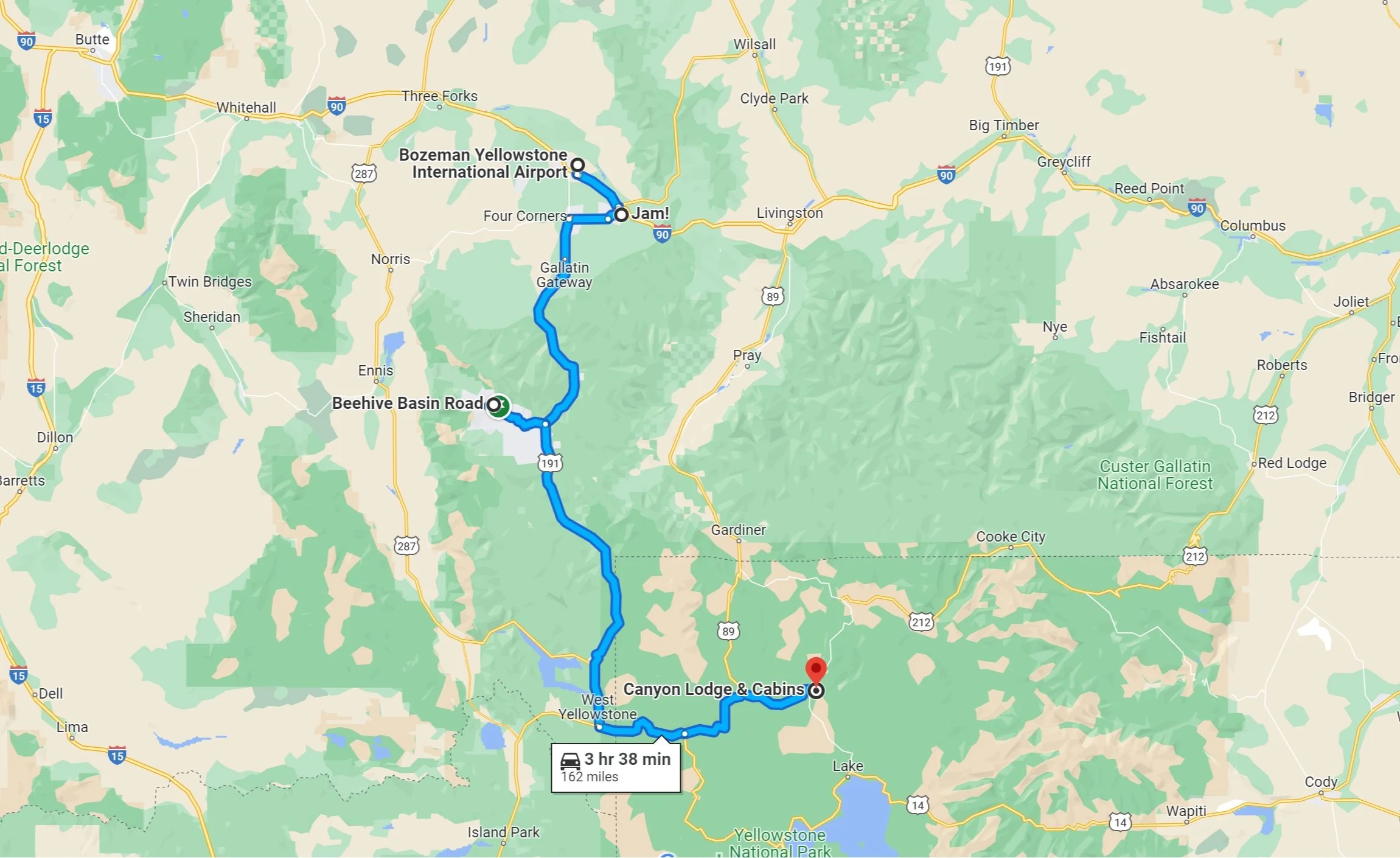
While we were planning, we decided that the most logical way is to either start in the north and work our way south, or vice versa. We flew into Bozeman (MT), drove south to Yellowstone and spent a few days there, continued south to Grand Teton and Jackson Hole, and flew home from Jackson Hole. Because Yellowstone is such as big park, we actually found accommodations inside of the park. It’s not cheap, but it is convenient. I found us a cute vacation rental condo for our days exploring Grand Teton, the town is called Wilson and was 25 minutes from the park.
Yellowstone National Park sits atop the world’s largest active volcano and is home to more than half the geysers on the planet. We didn’t know this until we got there, but 2022 was the 150th birthday of Yellowstone and the NPS! It was a total coincidence but neat that we visited at that time! Yellowstone was established as our first national park by President Ulysses S. Grant on March 1, 1872. According to the NPS, Yellowstone has the most active, diverse, and intact collections of geothermal features with over 10,000 hydrothermal sites.
A quick crash course in the geothermal features:
Fumaroles: steam vents, occur when there is so little water in the system that the water boils away before reaching the surface. Fumaroles are the hottest hydrothermal features in the park, with temperatures reaching 280°F.
Mudpots: acidic features with limited water supply that houses microorganisms that use hydrogen sulfide and convert it to sulfuric acid, which breaks down rock to wet clay/mud and creates the area’s pungent odor. Gases escape through the mud, causing it to bubble.
Hot springs: pools of hydrothermally heated water. Rain water seeps through the bedrock and is heated by the magmatic system before rising back to the surface. Convection currents constantly circulate the water, preventing an eruption. The colors of hot springs are due to the different types of thermophiles - the colorless and yellow thermophiles grow in the hottest water; orange, brown and green grow in cooler waters (but still hot). Hot springs are the most common hydrothermal features in Yellowstone
Geysers: hot springs with constrictions in their plumbing, which causes them to periodically erupt as pressure builds up. The surrounding rock prevents the water from boiling, and the weight of the water itself adds to the pressure as the water heats. Geysers erupt as the water is pushed past the surface to vent and release the pressure in the system. Geyers are the rarest of the hydrothermal features, but there are more geysers in Yellowstone than anywhere else in the world. Most geysers are unpredictable as to when they will erupt - but Old Faithful’s eruptions are somewhat predictable.
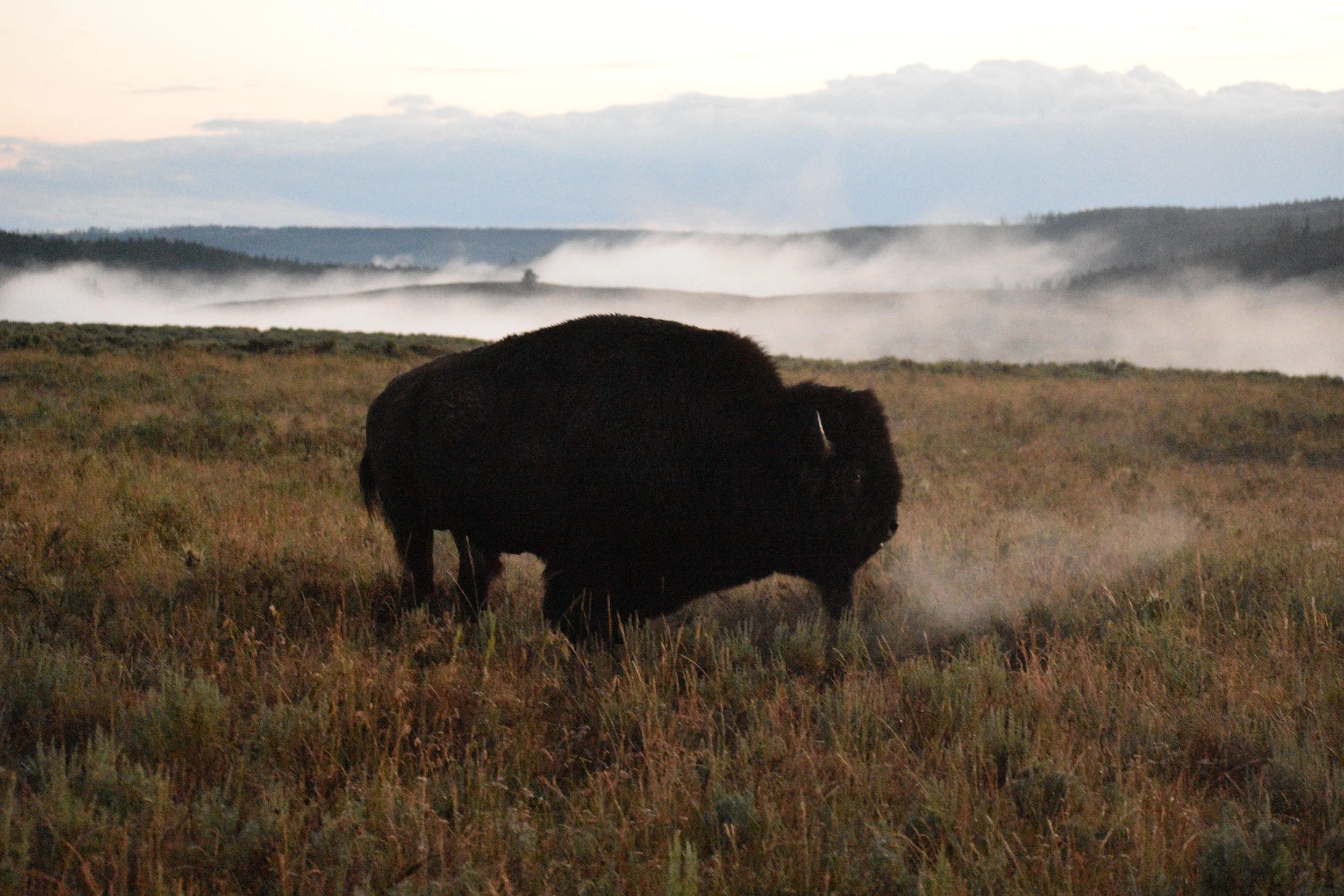
Aside from the geothermal features, Yellowstone is known for the wildlife. In preparation for this trip, I purchased a telephoto lens to try to photograph wildlife as part of my aspiring-photographer life goal. I also purchased a Pelican case with customizable inserts to transport my camera, lenses, tripod and other accessories safely across the country. This was my first time doing this. I was excited but also a little nervous to be traveling with so much expensive gear. But it was worth it! we saw a lot of wildlife on this trip, both in YNP and GTNP - we saw many bison, elk, moose, pronghorn antelope, bears, coyotes, foxes, snakes, a pelican, a Great Blue Heron, a bald eagle, and maybe more that I can’t remember.
Some quick fun facts about the wildlife:
Wild bison nearly disappeared from the planet. In 1901, only 25 bison remained in Yellowstone Pelican Valley.
Antelope are the fastest land animal in the US.
Bighorn sheep have two skulls - good for headbutting.
Two months before our trip, Yellowstone experienced devastating flooding and mudslides as a result of unprecedented rainfall and snowmelt that damaged the park’s infrastructure, including roads, water supply, waste water lines, power lines. You’ll recall the imagery of the road just gone and an entire house/building floating away. Luckily, we were still able to visit, but some of the northern parts of the park were still closed, such as the road to Lamar Valley.
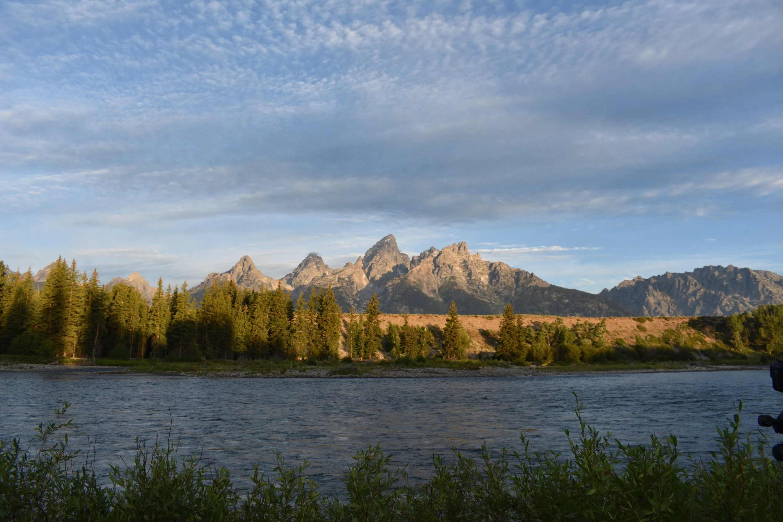
Yellowstone is 2.2 million acres, the second biggest in the lower 48 and ranking 8th overall (six of the eight Alaskan National Parks and Death Valley NP are larger than Yellowstone). Despite its size, Yellowstone is one of the most accessible parks I’ve been to. There’s plenty more to see in the backcountry that roads won’t show you, but you can cover a lot by driving. To document where we were on each day, I’ve included Google Maps for our days in Yellowstone. Grand Teton NP is significantly smaller, only 310,000 acres - but still grand! The park features the Teton range which is 40 miles long, the star being Grand Teton at 13,775 feet, Jackson Hole (the valley), the Snake River.


Itinerary
Day 1: Bozeman and YNP
We had an early morning flight out of Newark to Bozeman. Recently, when we have early flights, we’ve decided to drive to the airport and park our car there. This was the first time we’ve done it, and Kevin found a deal that we could part at the Hilton?? and they provided a shuttle to and from the airport.
Our flight was at 7:25, and we arrived in Bozeman at about 10:30. The Bozeman airport is one of the coolest airports (I guess being in Montana where hunting is big, there are taxidermied animals everywhere, giving the airport a cabin-feel.
While Kevin waited in line for our rental car, Chris and I waited with our bags and looked up where we should go to eat. We found a brunch place in downtown Bozeman called Jam! and headed there. The wait was long, so we put our names down and strolled the town. It’s a cute downtown like a small city. I had some sort of eggs benedict - the food was good and a great start to our adventure.
I have friends that go to Montana to ski, and in the summer there are hiking trails. I thought it’d be nice for us to have a short hike to stretch the legs before driving into Wyoming. We did part of the Beehive Basin trail in Big Sky. The hike wasn’t difficult, but the full trail is 6.6 miles which would have taken us a lot more time than we wanted, considering we still had a drive ahead of us. Chris brought his ukulele with him on this trip and serenaded us on every hike we went on. We definitely need to return to Bozeman and Montana to explore more!
Yellowstone NP is about two hours southeast of Big Sky. We entered through West Yellowstone, which seemed touristy and crowded - a taste for what was to come. The roads of Yellowstone make a figure eight, and our accommodations at the Canyon Lodge and Cabins were on the right side of the intersecting point. We checked into our cabin and had dinner at the Canyon Lodge Eatery, basically a cafeteria. Food was alright, but it gets very busy - long lines for food and sometimes tough to find a place to sit - because there are very few dining options within the park.


Day 2: Norris Geyser Basin and Mammoth Hot Springs
Because Yellowstone is so big and there is so much to see, we tried to be strategic in planning to do a region of the park a day. Our first day, we focused on the northern side of the park. Only the northwestern side of the northern loop was open - the northeastern side was still closed as a result of the flooding a couple months prior.
After breakfast at the Canyon Lodge Eatery, we drove east to Norris Geyser Basin, the hottest, oldest, most acidic and most dynamic geothermal feature in the park. It is part of one of the world’s largest active volcanoes. The highest temperature recorded in the park was here: 459°F 1,087 feet below the surface, and evidence supports that this area has had geothermal features for over 115,000 years. This area is also home to the tallest geyser in the world, Steamboat Geyser, 300 feet - two to three times as tall as Old Faithful, which erupts unpredictably - could be once every four days or fifty years. We hiked Back Basin along the boardwalks, a total of a little over two miles. Here, we read about Cistern Spring, which drains completely when Steamboat Geyser erupts. The colors of Cistern Spring and other hot springs are due to different types of bacteria and algae that each require a different temperature and environment to survive. As water flows away from its source, it cools, creating lower temperature environments for these organisms to thrive.
Just north of the Norris Geyser Basin area, we stopped at Roaring Mountain and Obsidian Cliffs. Roaring Mountain is a large acidic solfatara - a dormant volcano that still releases steam with sulfurous fumes. I don’t know if you can get up close and personal to it, because it’s dangerous, but the view from the parking lot was impressive in itself with steam rising from all over the mountain. It reminds me of Hell Valley in Noboribetsu, Japan (not that I’ve been there - yet). Obsidian Cliffs was just a couple minutes further north. Obsidian is formed when magma rich in silica and lava cools without forming crystals (magma is molten rock underground, lava is molten rock that has come through to be above ground). It forms a black glass. Normally, obsidian is found in small pieces like rocks or pebbles, but Obsidian Cliffs is a giant 98 foot tall wall of obsidian.
We continued north to Mammoth Hot Springs, an area of travertine terraces near Fort Yellowstone. Rain water and snow soak through the ground and are heated by the volcano’s magma system underground. As the water rises, it dissolves the calcium carbonate of the limestone rock, leaving behind travertine. There is a Visitor Center and museum in the old fort buildings. In the years following its designation as our first National Park, some people were more interested in exploiting the park’s resources as opposed to protecting them (hunters/poachers, developers, etc). When Congress refused to help protect the park, Yellowstone turned to the US Army which helped to preserve the park for 32 years (1886-1918).
We made a quick stop at Artists’ Paint Pots Trail, about a mile long trail that winds through hot springs, mud pots and small geysers. This was our first encounter with mud pots, and they might be my favorite! Hot mud flies and splatters, and creates a mud symphony at the same time. Minerals tint the mudpots giving this area its name of the paint pots.
On our way back to our cabin, we drove past Virginia Cascade - it’s an offshoot from the main road, and we happened upon bison also traveling on the same road, which turned out to be the highlight of this detour, instead of the falls!
After a little cat nap, we headed to the Lake Yellowstone Hotel (to the south), through Hayden Valley. Two of the best areas to see wildlife are Hayden Valley and Lamar Valley - the latter of which was closed due to the flooding. We did see wildlife several times in Hayden Valley, the first time was on this drive to dinner. There were bison on the side of the road, and Kevin got a video of one grunting with steam coming out of its mouth and nose, as the temps were dropping.
We had dinner at the Lake Yellowstone Hotel Dining Room - a much nice experience than the cafeteria by our cabin. Reservations were required here, and our reservation was for 21:45. The food quality was much better, but I don’t remember what I ate. It was late by the time we got back to our cabin, and we turned in for the night.


Day 3: Mount Washburn, Grand Canyon of the Yellowstone and Hayden Valley
We started the day with a hike up Mount Washburn (7.28mi), starting from the Dunraven Pass Trailhead. From the car, we saw bighorn sheep, but we didn’t encounter any on the trail. It’s a nice trail, fairly wide, steep at times but not consistently, with fabulous views the whole way up. The summit is over 10,000 feet high with panoramic views. Near the summit as you approach the fire lookout, the trail becomes sprinkled with obsidian. The guys had a fun time searching for pieces along the trail, as the sun reflected light off the rock.
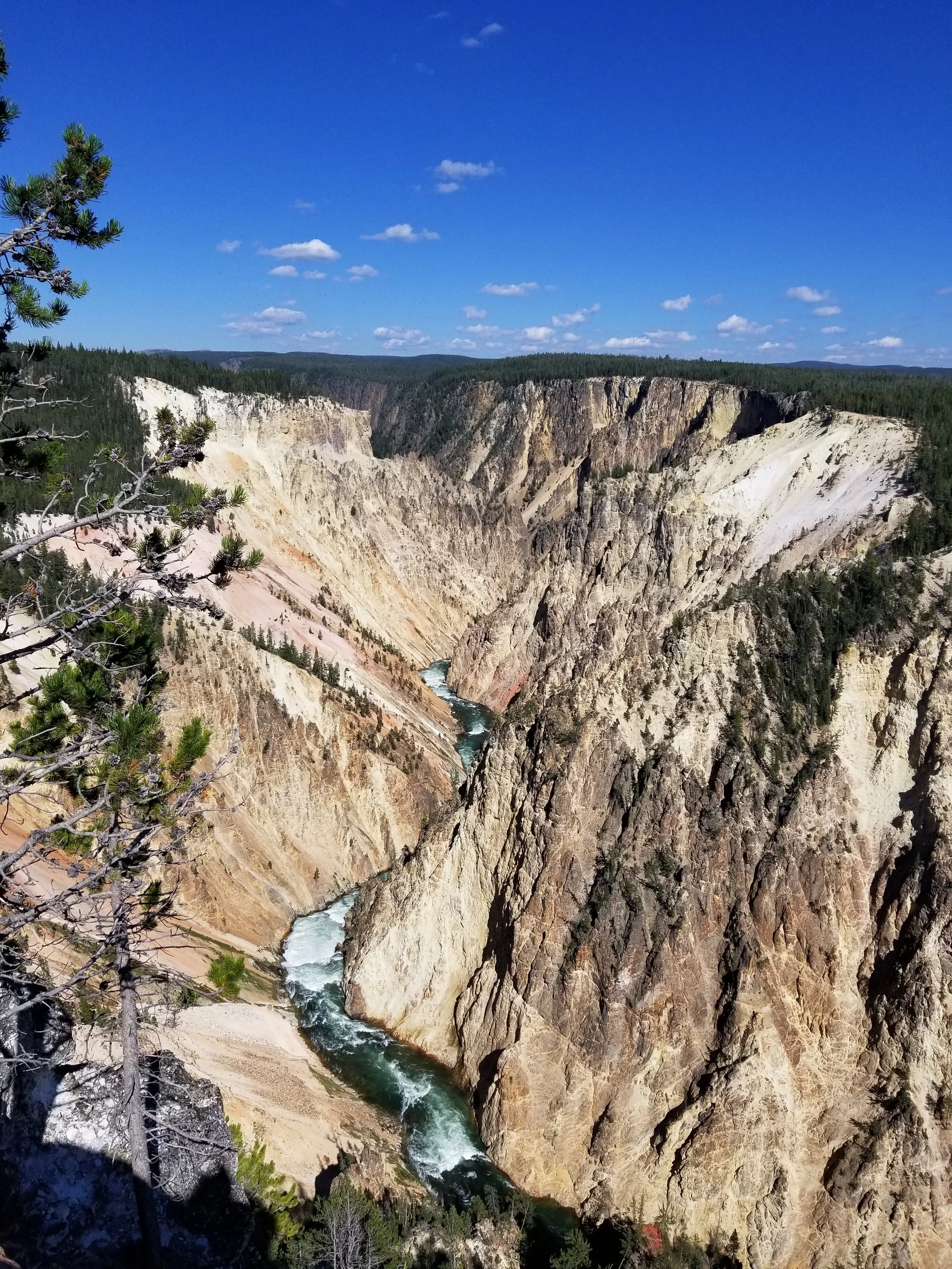
The Grand Canyon of the Yellowstone River has been formed over hundreds of thousands of years as the Yellowstone River carved its way through the rocks. Hydrothermal activity has weakened the rhyolite, making it softer and more susceptible to erosion. Where the river flows through the Upper Falls and Lower Falls, the rock volcanic rock is more resistant to erosion. Some hydrothermal features can be seen on the canyon walls as puffs of steam. This area is sprinkled with viewpoints: Brink of the Upper Falls, Artist Point, Lookout Point, Grandview Point, Inspiration Point.
Having only been to the Lake Yellowstone Hotel at night, we went back to see the lake itself during the day. Yellowstone Lake is the largest high elevation lake in North America, at 7,733 feet. It is about 20 miles long and 14 miles wide, and freezes over completely in the winter. Yellowstone Lake has the largest population of wild cutthroat trout (a Pacific fish) in North America - even though the lake drains to the Atlantic. Scientists believe that the river used to drain to the Pacific many years ago.
As part of our afternoon adventure, we stopped at Hayden Valley, hoping to see more bison, as we had the night before on our way to dinner. We parked the car, crossed the street and climbed a hill, where a hoard of people had collected. We’d packed a pair of binoculars that Kevin and Chris were using. I set up my tripod and telephoto lens to try to see what they were seeing. We spotted coyotes trying to hunt a deer, a herd of bison, and later, some elk. When we changed to a position down the road to photograph bison, Kevin and Chris found a way to take phone photos through the binoculars for additional zoom - our binoculars came with a mount!
We had dinner in the Canyon cafeteria and I think this was the night we had the fall-off-the-bone chicken.


Day 4: Upper Geyser Basin and Mud Volcano
We had breakfast at the Old Faithful Inn, which was great - it’s a buffet and the food was good. After breakfast, we strolled over to wait for Old Faithful to erupt. We were early, so we managed to get a good spot and set up the tripod. Old Faithful is one of nearly 500 geysers in Yellowstone and one of six that park rangers currently predict. Normally, Old Faithful erupts at an interval of 98 minutes plus/minus 10 minutes. It releases 8,000 gallons per eruption at speeds at least 700mph, reaching approximately 187 feet.
Yellowstone Volcano’s reservoir of partially molten rock (magma) is about five miles below the surface of Upper Geyser Basin. This area has the largest concentration of geysers on Earth, with 150 geysers in one square mile, including Old Faithful. We spent the day exploring the Upper Geyser Basin area, including Black Sand Basin and the colorful Grand Prismatic Spring. We opted to see Grand Prismatic from above, at the overlook. Grand Prismatic Spring is Yellowstone’s largest hot spring, 200-330 feet in diameter and 121 feet deep. From Grand Prismatic Overlook, we continued onward through a flat forest to Fairy Falls (about six miles total).
Back at the Visitor Center, we checked the board to see when Old Faithful would erupt again - we were in luck! It was soon but not so soon that had to rush, but there was another nearby geyser that was about to erupt! We went outside and caught Beehive Geyser! It typically only erupts once or twice a day, spewing water that is 198ºF with a pH of 8.3, but it lasts 4-5 minutes and seemed higher than Old Faithful - NPS reports 150-200 feet. It was quite a show - it just kept on going! And we still had time to get a good view for Old Faithful round two!
Our next stop was the Fountain Paint Pot Trail, a mile long trail on boardwalk that passes by all four types of hydrothermal features. Our favorite was the area by Jelly Geyser and Spasm Geyser. Finally, we visited the Mud Volcano Area before dinner in the Canyon cafeteria.


Day 5: Cascade Canyon
After breakfast at the Old Faithful Inn, we drove south to Grand Teton National Park, stopping at the Continental Divide.
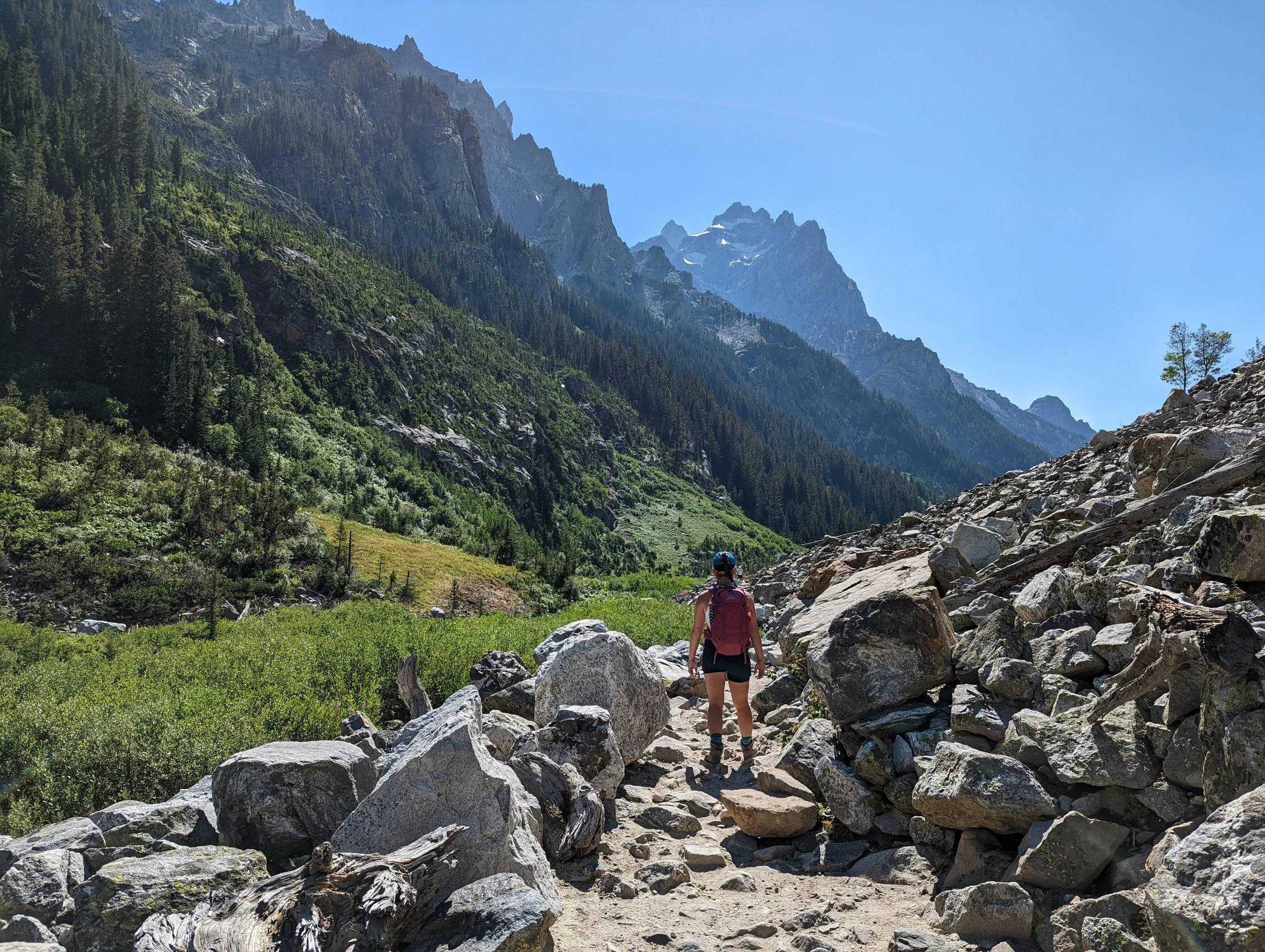
We took the boat across Jenny Lake ($20 per person, round trip) and hiked Hidden Falls to Inspiration Point to Cascade Canyon. We had lunch at Inspiration Point, and warded off lunch thieves (chipmunks) who were very much not afraid of us - not a good sign, don’t feed the wildlife! As we continued into Cascade Canyon, we were totally exposed and thinking about turning around, but people hiking the opposite direction as us told us there was a moose ahead! We had to continue on to see it, and would have missed it if it weren’t for a group of three or four other people photographing it. The moose was maybe a hundred feet or so off the trail, lounging and sunbathing on the side of a creek.
Such excitement seeing our first moose! We drove south to exit Grand Teton, through Jackson and to our vacation rental condo. It was difficult to find in the dark, but we made it! We grabbed a chill dinner at Snake River Brewery and turned in early because I had big plans for the next day!


Day 6: Delta Lake
I scheduled an early wake up call for our first Teton adventure, which turned out to be my favorite day. We stopped at Cowboy Coffee for the guys to get coffee (and breakfast sandwiches) - it was the only place open early enough.
We were at Lupine Meadows Trailhead at 7AM. Hiking to Delta Lake was the toughest - but most rewarding - trail we did all week. There were times when I didn’t know if we would make it to the top. Luckily we made some trail friends, Britt and Billy, and kept each other going. The trail to Delta Lake starts on the Valley Trail, then branches to the Garnet Canyon Trail, and then onto an unmarked, unmaintained trail to the lake. This trail had it all - flats through the forest, switchbacks overlooking lakes and the valley, scrambles across boulder fields. We even saw a mama bear and two cubs, from a distance, of course! It was challenging but so worth it. The last part of the trail, before you see the lake, is very steep. The lake is gorgeous! If you know me, you know I’m easily entertained, so I just love that the peak that sits behind the lake is called Disappointment Peak. The water was so cold - our thermometer read about 40ºF. We clocked in nine miles round trip. It took us three hours to get to the lake (according to time stamps on our photos), we spent two and a half hours at the lake and it took us a little over two hours to hike down. You can climb here too - we ran into a couple groups of climbers on the trail. It’d be cool to say you’ve climbed Disappointment.
After our hike, we needed to refuel. We had walked past this old theater that had been transformed into a pizza place with wood-burning pizza ovens, so we had to go. Hand Fire Pizza in Jackson is Kevin-approved! We had a Pesto-G (pesto, mozz, goat cheese, peppers, red onions), the Chew-baca (bacon, arugula and honey drizzle), and I think the Extra Peppy Funghi (giant pepperoni, different kinds of hot peppers, mushrooms).
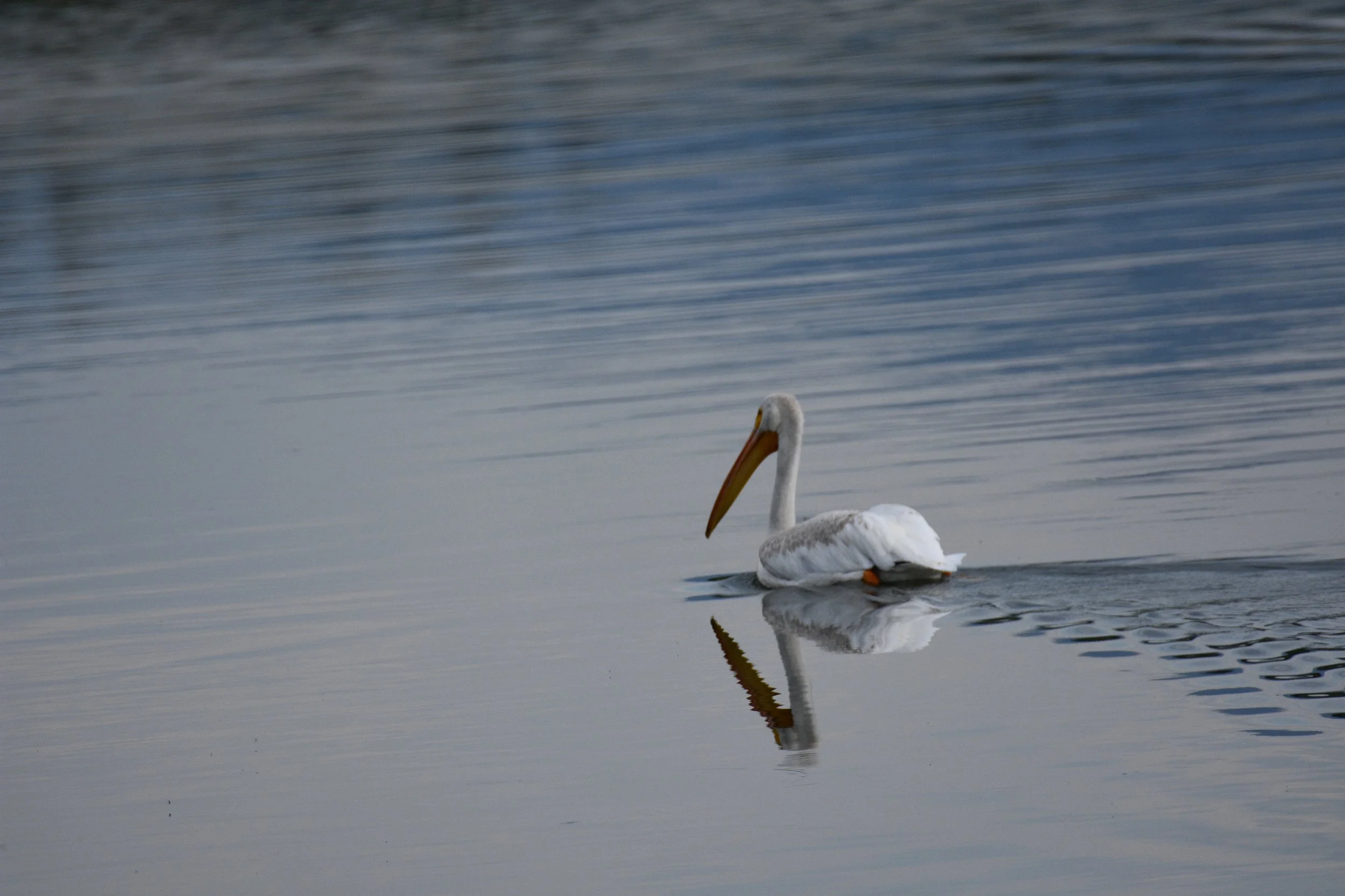
We took a drive up Signal Mountain - you can hike it, but there’s also a road. At the summit we were treated to panoramic views of the Teton range and Jackson Hole. As sunset was approaching, we drove around the park, stopping at pull offs, hoping to spot wildlife. I made sure we visited the iconic Teton spots like Oxbow Bend - this is where we saw the pelican and Great Blue Heron - Schwabacher Landing - where I hoped to spot moose (we didn’t) - and Mormon Row.
When we turned into the neighborhood our condo was in, there was a big SUV just sitting in the middle of the road. We stopped behind them and were really confused - until we realized they were watching a mama moose and two moose calves wandering the parking lot, eating the landscaping! It was dark and a little hard to see, but we observed them for a while, until we thought we could safely drive around them.


Day 7: A Chill Day in the Park and in Town
We took it easy after the previous day’s strenuous hike - a leisurely morning and a nice drive into the park where we happened to spot bison and antelope. We had a picnic lunch at Colter Bay, which is gorgeous but the water level of the bay is incredibly low. I asked a ranger why, and learned that the park doesn’t own the water, so since there have been pretty serious droughts there the past few years, the water was drained to flow west into Idaho to grow our potatoes. The underlying reason is climate change. There has been less precipitation, less snow and therefore less snow melt which would normally feed the lake (and would also water the potato crop so they wouldn’t need to drain the lake). The Teton glaciers have decreased 40% in 40 years.
After lunch we decided to do a short, easy hike. The park has six morainal lakes at the base of the mountain range: Jackson, Leigh, Jenny, Bradley, Taggart and Phelps. We opted for Taggart Lake for no particular reason, but only got maybe half a mile in before it started to thunderstorm and we decided to turn around. Instead, we went to the visitor center which had a little museum, then into town and wandered around some shops for a while. The outdoor apparel store, Stio, is based in Jackson, and our elopement photographer wears Stio when she does winter shoots, so we checked it out. They had a guitar hanging on the wall and a promotion that if you play a song, you get a discount. Chris asked if he could play his uke instead of the guitar and they agreed, so he ran out to the car to grab his uke. He played Dream A Little Dream of Me, and the young girl at the check out counter definitely did not know the song, but other customers in the store did - one older gentlemen even started singing along with Chris as he shopped!
I had made us a reservation at 17:30 at the Gun Barrel, steak and game house. This place was so cool. It felt like a cabin, with taxidermied animals on display, and they made it look like a museum. We shared a bison carpaccio as an appetizer, Kevin and I had ribeyes and Chris had an elk chop. All the food was really good. As we sat at our table, surrounded by all the animals, we started a game - who would win in a fight, this or that? We started doing research on some of these animals - specifically the big horn sheep, elk, moose, bear, bison. I personally don’t remember who would win now, but Chris and Kevin probably do.
As we were driving around the park previously, our GyPSy guide informed us that moose like to eat willow, so we’d made a mental note to return to the Willow Flats at dusk. Our early dinner was unintentionally timed perfectly for this. There are couple of dirt trails in the area that descend to nice vantage points with the mountains behind the field. We didn’t get to see any moose, but we did see elk.


Day 8: A Chill Day at Jenny Lake
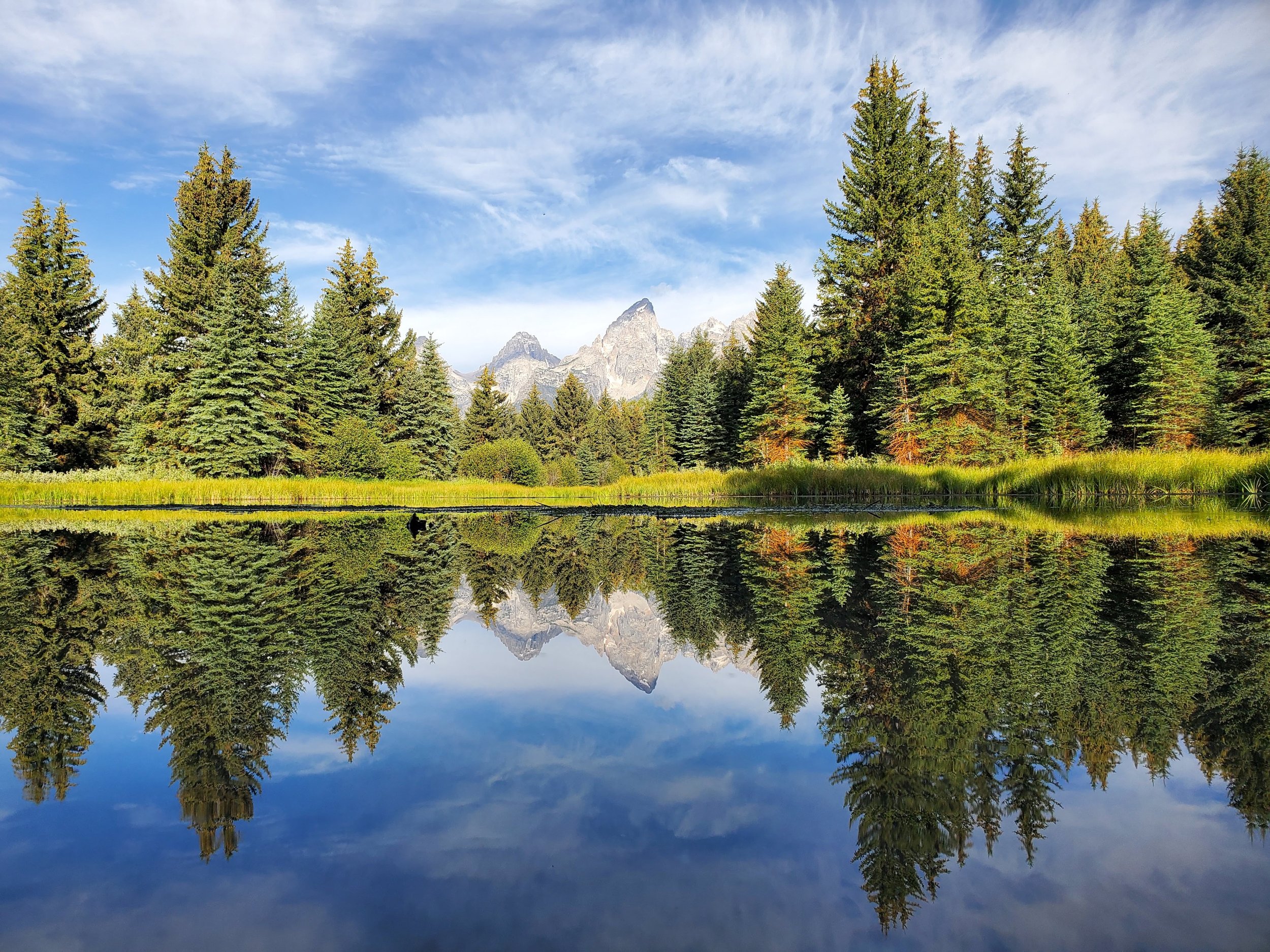
We woke up early for sunrise in hopes of seeing wildlife (we didn’t). Schwabacher Landing is really the prime sunrise spot. Since we had explored the area in daylight prior, we knew what to expect and generally where to go, and it made it much easier to navigate in the dark. We got there at 6AM and had it to ourselves for just a short time - we weren’t the only ones with this idea. The area of Schwabacher where you can capture the reflection of the mountains in the calm water of dawn is a popular viewing point. There is a trail that leads to a more remote field with, in my opinion, a better view of the mountains. Here, we were able to see alpenglow over the Tetons, which made the early wake up call worth it. We spent about three hours here, watching the sunrise and doing a photoshoot.
We went back to the Jenny Lake area, which is tough to find parking. We had been here our first day in the Tetons, but didn’t get to explore the lake itself too much - we had basically used it as a starting point for our hike. There are trails all around the lake, we walked some of them but didn’t go all the way around - the Jenny Lake Loop is seven miles around the lake. We found a quiet place to relax on the “beach” which is more pebbles and gravel than sand. We hung out, ate lunch, did a nap relay and played in the lake for a couple hours. The water was so refreshing and amazingly clear, but the rocks were slippery and tested our balance.
In the afternoon, we stopped at Persephone Bakery for cappuccinos and pain au chocolat. We hung out in Jackson, wandered through the shops, stopped for ice cream at Moo’s Ice Cream. For dinner, we went back to Hand Fire Pizza.

Day 9: The trip home
Our flight home from Jackson was at 7AM. We got to the airport at about 4:30 - and the airport wasn’t even open yet. You could go inside, but there was no staff, the check in counters weren’t open, security wasn’t open. We were able to return our rental car at the key drop, but then we waited in the airport I think until 5AM. JAC is a small airport with like eight gates, one waiting area and one convenience store for all the gates. In my opinion, you really don’t need to arrive so early for your flight because the airport is so small.

Concluding Thoughts
I liked our experience at the Xanterra property in Yellowstone. As I mentioned before, it’s not cheap, but it’s nice to be in the park. The cabin we stayed in was pretty rudimentary and rustic, but it had everything we needed. There is a food court/cafeteria near the lodge too. The food was all right, but expensive for what you got. I do remember one night they served chicken, which was fall off the bone tender.
There is just about no cell service in the Yellowstone, and wifi isn’t great either. Be sure to download offline maps.
As we drove around Yellowstone, we used the GyPSy app for narration and to learn about history.
The geothermal features are incredibly hot and dangerous. Despite the signs posted all over the park, people die and get injured by doing stupid things. Stay on the boardwalks, don’t touch any of the hot springs or mud pots, etc.
This is bear country. We rented bear spray from Bear Aware in Canyon Village and returned it at the airport. They show you how to use it, when to use it, characteristics of different bears you may encounter. You cannot fly with bear spray. There are multiple locations for pick up and drop off.
Keep Wildlife Wild. Stay 100 yards (a football field) away from bears and wolves, and 25 yards away from other animals. And never feed the wildlife. That means pack it out, even if it’s “biodegradable” like an orange peel or apple core or cracker - these things typically take years to biodegrade and an animal will surely get to it sooner than that.
Many “trails” in Yellowstone are boardwalks, standing above the geothermal features. We were in our sneakers most of the time (the exception being when we hiked Mount Washburn).
I’m glad we visited Yellowstone, and all the geothermic features and wildlife are cool, but it’s not my first choice in terms of type of park. Grand Teton was more my cup of tea with the mountains and lakes and hiking. Yellowstone was more a drive up and look experience, which is great because its accessible to everyone, but that also means it was very crowded and I’m more an off-the-beaten-path kinda gal.
The town of Jackson is super cool, loved the vibe there. While it is touristy, it’s got a lot of character.
You can access the official NPS Map of Yellowstone and Grand Teton NPs here.
The two big hikes I had aspirations of doing in the Tetons were Sunrise, Amphitheater and Delta Lakes (we only did Delta Lake - adding the other two lakes would have added another three miles) and the Paintbrush Canyon - Cascade Canyon Loop (a twenty mile loop). We did part of Cascade Canyon. People backpack the loop, but from what I’ve read, Lake Solitude at the far end of the loop sounds like a place I’d really enjoy.